Chapter 2
2.1 City of San Mateo’s Sustainable Street Effort
The City of San Mateo was one of two primary municipal partners in the development of the GIS Site Locator Tool. San Mateo is a city on the San Francisco Peninsula with a population of about 100,000 people. When the Green Plan Bay Area project began, the City was in the process of developing a Sustainable Streets Plan. This plan combined two other city planning efforts, a Complete Streets Plan and a Green Streets Plan, into one comprehensive plan. The Complete Streets Plan balances development and redevelopment of all modes of transportation including pedestrian, bicycle, cars, and public transportation in order to create streetscapes accessible to all transportation modes. The Green Streets Plan creates a blueprint for urban greening and returning some more natural watershed function and attributes to the cityscape. One of the primary benefits for urban greening and implementing green infrastructure is to improve the water quality of stormwater runoff that drains to the Bay. In addition, the City also desired other green infrastructure benefits such as beautification, increased areas of urban habitat, and traffic calming that can help reduce the cost to benefit ratio associated with green infrastructure implementation. Together, these plans create a re-visioning of urban streets for planning and integrating transportation modes with urban greening.
2.2 Case Study Objectives
The Project Team (staff from the City of San Mateo and City of San Jose, other municipalities, BASMAA, and technical advisors) held three meetings to identify Toolkit needs and useful functionality that would be most essential for city planning efforts. Site Locator Tool recommendations from the TAC included adding public/private ownership delineations on map outputs, enabling the Regional Base Analysis an optional part of the Tool, and identifications of useful data layers for running the Tool. Once the beta version of the Site Locator Tool was developed, the development team worked with the City of San Mateo to start the pilot effort.
One of the primary goals for San Mateo was to identify potential GI locations for inclusion in the Sustainable Streets Plan (Figure 2-1). Since this plan was focused on redeveloping streetscapes, the most useful data pertained to street width, sidewalk width, existing sidewalk planters, and areas of damaged streets and sidewalks that could be considered for future repair. San Mateo plans to capitalize on combining Green Infrastructure with multiple modes of transportation so the City wanted to include existing and potential pedestrian paths (along with streets and sidewalks) as potential GI locations. The City was most interested in identifying locations for bioretention features so this feature type was selected and run through the various analyses. The City elected to include the Regional Base Analysis in the Tool run. This analysis removes locations for consideration that don’t meet the base criteria which can result in the exclusion of many locations that could be areas for GI but may need additional engineering.

Figure 2-1. Design guidelines for City of San Mateo street zones including planned zones for Green Infrastructure implementation (Courtesy of City of San Mateo).
2.2 Project setting
In San Mateo, the GIS Site Locator Tool was demonstrated in five discrete watersheds including Borel Creek, Laurel Creek, Leslie Creek, Poplar Creek, San Mateo Creek, as well as multiple unnamed drainages (Figure 2-2).
2.3 Site Locator Tool: Data layers used and decision process
The GIS Site Locator Tool integrates regional and local GIS data and uses these data, through an identification, ranking and weighting process, to locate potential GI locations at a watershed scale. Data accuracy is an important determinant in the accuracy of map outputs produced by the Tool. The quality, scale and accuracy of the input data will determine the quality, scale and accuracy of the output maps. Therefore, it is highly beneficial to use more accurate and local data when available. When using more regional scale data layers for analyses, such as the opportunities and constraints ranking analysis, the user can weight and rank these layers to reflect the confidence in local accuracy of the data. There are many regional GIS data that are included in the Tool (Table 2-1) and additional regional data sets can be added as well. Local data sets can be added to the Tool in order to help identify potential locations that meet the goals and planning needs of each city. Each municipality will identify a set of questions or goals to answer or meet prior to running the Tool. These questions or goals become the drivers for deciding which data sets to include.
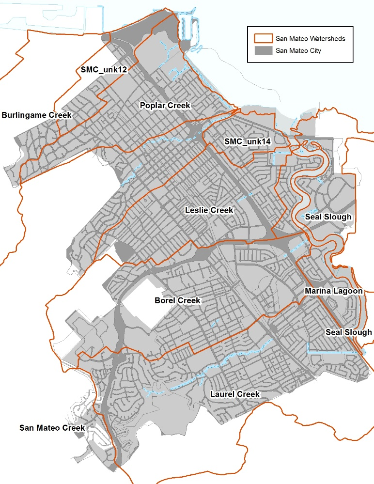
Figure 2-2. Map showing City of San Mateo watersheds and drainage areas included in the demonstration project. Orange lines delineate each watershed boundary. Note that some watershed boundaries are outside the City.
Table 2-1. Regional GIS data layers included in the Site Locator Tool.
|
GIS Data Layer Name |
GIS Data Layer Description |
|
CPAD_2014a2_Holdings |
California Protected Areas database released in the first half of 2014 |
|
FEMA_NFHL |
National Flood Hazard Layers for all BA counties |
|
Employment_Investment_areas_SCS |
From ABAG's data webpage |
|
Priority Development Areas_Current |
From ABAG's data webpage. Priority Development Areas (Current) - This feature set contains changes made to Priority Development Areas since the adoption of Plan Bay Area. DO NOT USE this feature set for mapping or analysis related to Plan Bay Area. |
|
K_12_Schools |
Schools in the bay area (point data) |
|
NLCD2011_PercentImpervious |
Percent Impervious data from the 2011 National Land Cover Dataset |
|
OSM_Buildings |
Open Street Map layer for the Bay Area _Late2014 |
|
OSM_Libraries |
Open Street Map layer for the Bay Area _Late2014 |
|
OSM_Parking |
Open Street Map layer for the Bay Area _Late2014 |
|
OSM_Parks |
Open Street Map layer for the Bay Area _Late2014 |
|
OSM_Schools |
Open Street Map layer for the Bay Area _Late2014 |
|
OSM_Streets |
Open Street Map layer for the Bay Area _Late2014 |
|
R2_CARI_PublicV |
California Aquatic Resource Inventory for Region 2 |
|
Regional_Bike_Facilities_Bay |
Regional bike facilities for the Bay Area |
|
RWQC_RB_2 |
Region 2 Water Board Boundary |
For the city of San Mateo, the primary driver for implementing GI was the Sustainable Streets Plan. Since this plan focused on streetscape redevelopment, spatial data that quantified street and sidewalk attributes and integrated Complete Street concepts were important data for inclusion in the Tool. The City elected to run each of the Tool analyses including the Regional Base Analysis.
Primary locations identified by the City were public parks, pedestrian trails, wide streets, wide sidewalks, existing planters, and parking lots. The city also identified planning opportunities such as areas planned for redevelopment (PDAs), areas of damaged streets/sidewalks, Greenway Networks, and Regional Bike Facilities as well as constraints to GI implementation including sidewalks with large trees, fire lanes, and narrow streets. These opportunities and constraints were then categorized into factors such as funding opportunities, local development opportunities, community visibility, and installation feasibility. These factors were then weighted to produce a relative ranking of areas for potential GI implementation,
The City also included a data layer that identified City-owned parcels in the ownership analysis which allowed for a public/private delineation of locations in the map outputs. The last analysis removes areas that are not feasible GI locations such as wetlands, riparian areas, and areas with utility mains close to the surface. The City excluded all areas intersecting existing wetlands and the San Mateo Lagoon in this analysis. Table 2-2 shows the regional and local GIS data layers included in the Site Locator Tool for the City of San Mateo.
2.5 Site Locator Tool Results
Running the Site Locator Tool with the City of San Mateo was an iterative and interactive process. The first round of conversations with the City focused on identifying street data that had spatial attributes for measuring existing street width. During subsequent conversations, additional data sets such as existing and potential pedestrian trails, sidewalk width, areas of existing sidewalk planters, and regional bike facilities in or identified as additional data that captured certain aspects of the Sustainable Streets Plan. This progression shows how GIS data layers can be added and removed, rankings and data layer weights can be changed. Additionally the Tool can be rerun by including or excluding any of the analyses. This iterative process can be refined as questions and goals change or more accurate local data are available. Based on selected regional and local data layers and the City’s ranking and weighting of these layers, the Site Locator Tool identified 18 acres of City-owned property or right-of-way as highly ranked locations for potential GI implementation, 113 acres as moderately ranked, and 11 acres as lower ranked locations (Figure 2-3). In total, 142 acres were identified as potential locations for Green Infrastructure. Higher ranked sites were the result of relatively higher factor weights on Priority Development Areas and funding opportunity data layers.
Table 2-2. Local and regional GIS data layers included in the Site Locator Tool for the City of San Mateo.
|
GIS Data Layer Name |
GIS Data Layer Description |
Data Layer Type |
Analysis |
|---|---|---|---|
|
Sidestreet parking |
Side Parking polygons on one lane streets (Where Width from Street Saver data* allowed for the minimum dimentions of lanes, medians and parking spaces for each street type and context from the San Mateo Sustainable Streets report) |
Regional/Local |
Locations |
|
Sidestreet parking |
Side Parking polygons on one lane streets (Where There is no Width value from Street Saver data and the minimum dimentions of all street comonants for each street type and context from the San Mateo Sustainable Streets report is assumed) |
Regional/Local |
Locations |
|
Sidestreet parking |
Side Parking polygons on multi lane streets (Where Width from Street Saver data* allowed for the minimum dimentions of lanes, medians and parking spaces for each street type and context from the San Mateo Sustainable Streets report) |
Regional/Local |
Locations |
|
Sidestreet parking |
Side Parking polygons on multi lane streets (Where There is no Width value from Street Saver data and the minimum dimentions of all street comonants for each street type and context from the San Mateo Sustainable Streets report is assumed) |
Regional/Local |
Locations |
|
Sidewalk |
Sidewalk Polygons (Where the width attribute from the San Mateo Sidewalk layer allows for the mimimum dimentions of sidewalk compoents for each street type and context according to the San Mateo Sustainable Streets report and allowed for a GI installation in the sidewalk furniture zone) |
Local |
Locations |
|
Sidewalk |
Sidewalk Polygons (Where there is no width attibute from the San Mateo Sidewalk layer, and minimum dimention of sidewalk compoents from the San Mateo Sustainable Streets report are assumed). |
Local |
Locations |
|
Parking lot |
Parking Facilities quried from San Mateo's facility polygon layer |
Local |
Locations |
|
Pedestrian Trails |
San Mateo's Pedestrian Trail layer buffered 2 ft on both sides (4 ft wide) |
Local |
Locations |
|
Potential Pedestrian Trails |
San Mateo's Potential Pedestrian Trail layer buffered 2 ft on both sides (4 ft wide) |
Local |
Locations |
|
Parking_OSM |
Parking polygons querried from SF Bay OSM polygons (downloaded in August 2014) |
Regional |
Locations |
|
Parks_OSM |
Park polygons querried from SF Bay OSM polygons (downloaded in August 2014) |
Regional |
Locations |
|
CPAD_Areas |
California Protect Areas Database Polygons for the Bay Area |
Regional |
Locations |
|
Sidewalk planter |
Sidewalk Polygons that have a planter width value of 4ft or more |
Local |
Locations |
|
Sidewalk |
Sidewalk Polygons that have a width value of 8ft or more |
Local |
Locations |
|
Priority Development Areas |
Bay Area Wide Priority Development Areas from ABAG |
Regional |
Opportunities and Constraints |
|
Storm Line |
A 25 ft. buffer from the San Mateo Storm Line layer |
Local |
Opportunities and Constraints |
|
Storm Line |
A 50 ft. buffer from the San Mateo Storm Line layer |
Local |
Opportunities and Constraints |
|
Catch basin |
A 25 ft. buffer from the San Mateo Storm Catch Basin Layer |
Local |
Opportunities and Constraints |
|
Street Trees |
A 20 ft. buffer from the San Mateo Urban Tree layer |
Local |
Opportunities and Constraints |
|
large trees ( > 20) |
A 30ft buffer around trees that are over 20ft in circumference from the San Mateo Urban Tree layer |
Local |
Opportunities and Constraints |
|
Street Lights |
A 15ft buffer around street lights from the San Mateo Street Light layer (+5ft for spatial inacuracies between layers) |
Local |
Opportunities and Constraints |
|
Narrow Street_Fire Running Lanes |
A 40 ft. buffer from a selection from the San Mateo Fire Running Lane layer (streets that were less than or equal to 40 ft. wide accounting for spatial inaccuracies in the data layers used) |
Local |
Opportunities and Constraints |
|
Regional Bike Facilities |
A 15 ft. buffer from the Bay Wide Regional Bike Facilities Layer from MTC (+ 25ft to account for spacial inacuracies between layers) |
Regional |
Opportunities and Constraints |
|
Streetside parking |
A Road polygon later create from San Mateo road centerlines buffered half width of that road (Street Saver data* width) taken from the San Mateo location street layer, where the width from Street Saver data* allows for the minimum width of street components for that particular street type and context as well as the minimum width of a bike lane |
Regional/Local |
Opportunities and Constraints |
|
Damaged Streets |
A Road polygon layer (San Mateo road centerline buffered by half of that street's width according to Street Saver data*) where PCI is less than or equal to 40, indicating that they are damaged roads and may need to be repaired soon |
Local |
Opportunities and Constraints |
|
Damaged Sidewalk |
San Mateo Sidewalk polygons that are indicated as having damaged curbs, gutter and or sidewalks |
Local |
Opportunities and Constraints |
|
GreenWay Network |
San Mateo pedestrian priority green way corridor from Ken Chen, Sep 2014 (buffered 85 feet to account for spatial inacuracies and missalignment of layers.) |
Local |
Opportunities and Constraints |
|
Streams |
A 500ft buffer from a subset of San Mateo's Stream layer where no Streams intersect San Mateo's Lake layer |
Local |
Opportunities and Constraints |
|
Lakes |
A 400ft buffer from San Mateo's Lake polygon layer |
Local |
Opportunities and Constraints |
|
Schools |
A 100ft buffer from San Mateo's School polygon layer |
Local |
Opportunities and Constraints |
|
Libraries |
A 100ft buffer from San Mateo's Library polygon layer |
Local |
Opportunities and Constraints |
|
City Hall |
A 100ft buffer from City Hall polygons selected from San Mateo's Facility polygon layer |
Local |
Opportunities and Constraints |
|
parks |
A 100ft buffer from a subset of San Mateo's Facility polygon layer where FACTYPE is = to "PARK" |
Local |
Opportunities and Constraints |
|
City-owned parcels |
San Mateo's city owned parcel layer |
Local |
Ownership |
|
CARI Wetlands |
CARI Wetland polygons: see http://www.sfei.org/it/gis/cari |
Regional |
Knockout |
|
SM_Lagoon |
Lagoon Layer from San Mateo |
Local |
Knockout |
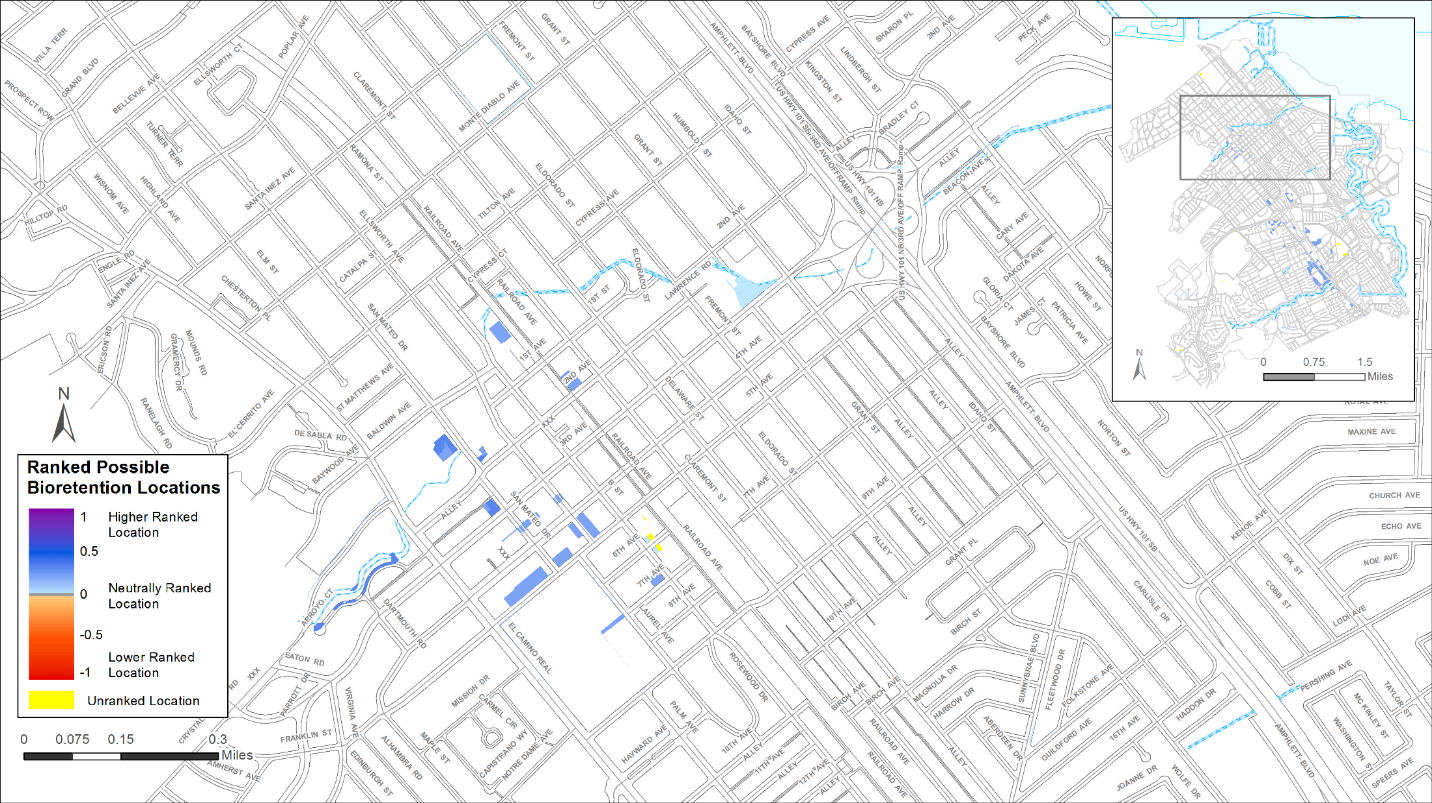
Figure 2-3 Map output of ranked potential bioretention locations in the City of San Mateo. Higher ranked locations are dark blue, lowest ranked locations are red and yellow designates unranked areas due to lacking data in those places
San Mateo and SFEI performed a remote data validation exercise in order to see how the Tool ranked areas previously identified for potential GI implementation. Specifically, Grant Street and Fremont Street were investigated to determine why one street ranked higher than the other. Grant Street was ranked higher than Fremont Street since it had a planned bike lane, which was given a higher weight in the Opportunities and Constraints Analysis. Delaware Street and Bay Meadows were unranked in the output because they were excluded as possible locations due to site characteristics deemed not feasible for implementing GI. Overall, many of the sites identified and ranked highly by the locator tool were also sites that were previously identified as potential GI opportunities by San Mateo. Furthermore, additional high ranked locations were identified which provided the City with additional locations to investigate further and to compare to the current GI plan.